Now and Then

AlanLichty

Moderator
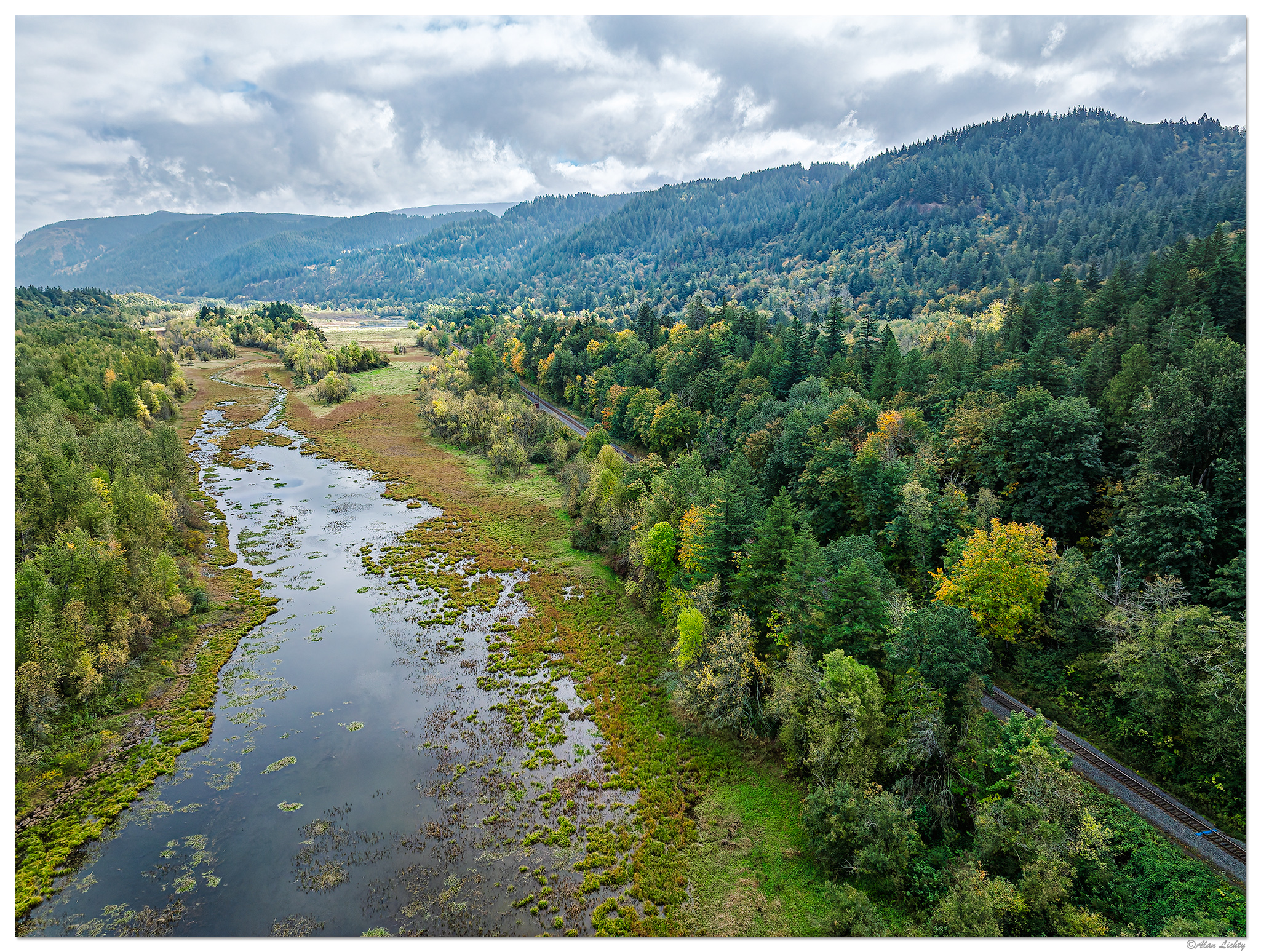
I was curious to compare what the area below Crown Point looked like prior to the construction of I-84 in the 1950's since it certainly looks like it all used to be a much larger wetland. After a bit of digging I stumbled across a postcard image that offers a good view to compare with a drone shot from a few weeks back.

Current scene:

DJI_M3P_RRockNow102025.jpg


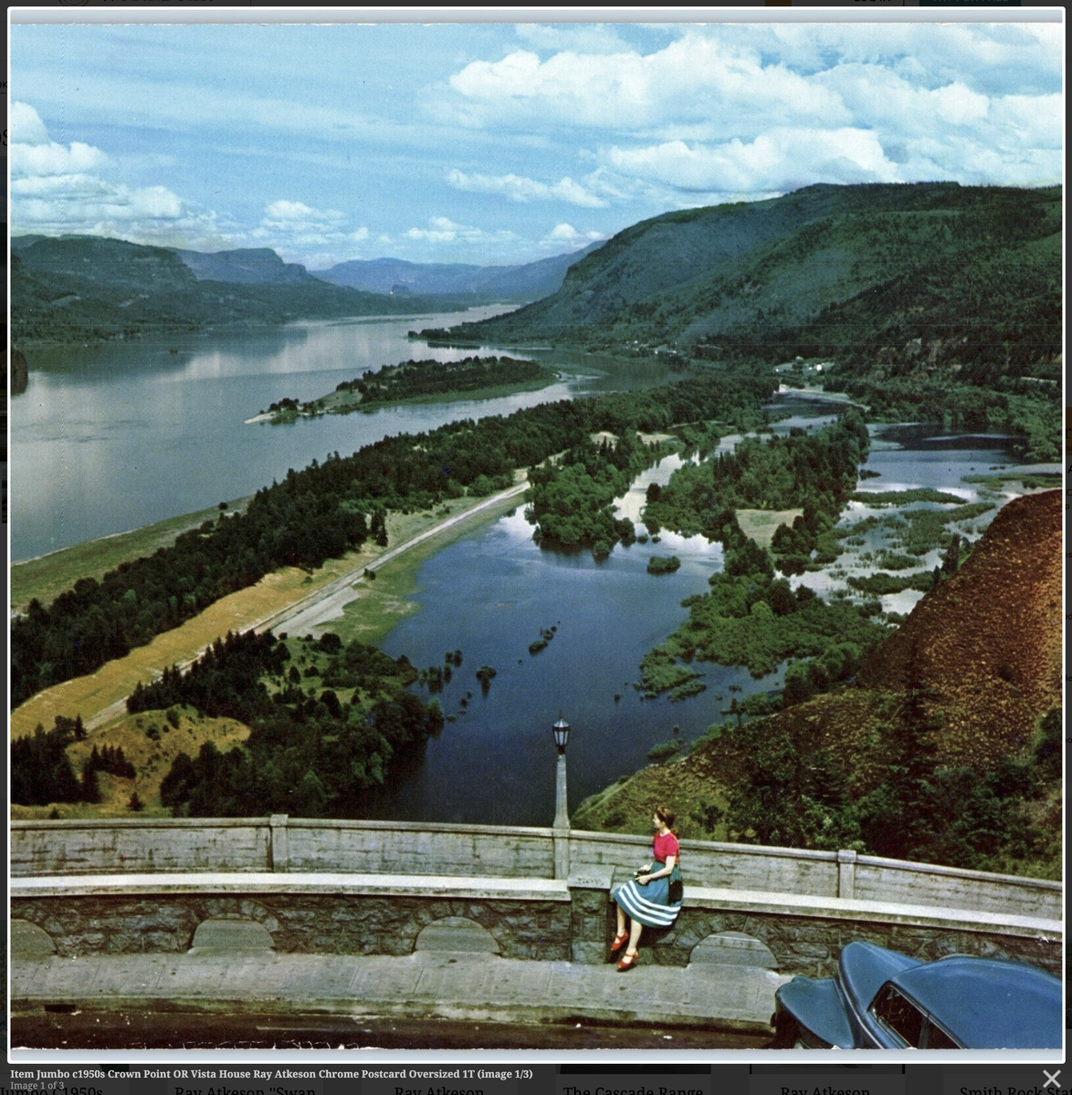
The view from Crown Point in the 1950's. The info I have is that the photographer is Ray Atkeson. Some of the islands in the wetlands are still visible as clusters of trees slightly elevated above the flat ground in the current scene. The freeway has diked off the old waterways in numerous places along the waterfall corridor portion of the Gorge. Interesting to note that bare hillsides in the hills above the river in the upper center of the postcard.

CrownPoint1950s.png


C&C always welcome.
 

Trent Watts

Well-Known Member
Wow. What a difference in the amount of water. Is that a seasonal thing or due to construction? The post card doesn't look like an autumn shot.
The lady in the postcard sure looks like she came from the 50's.
Thanks for the comparison shots Alan.
 

AlanLichty

Moderator
Wow. What a difference in the amount of water. Is that a seasonal thing or due to construction? The post card doesn't look like an autumn shot.
The lady in the postcard sure looks like she came from the 50's.
Thanks for the comparison shots Alan.
Thanks Trent - the bottom image is a postcard from the 1950's prior to the interstate freeway being built across this wetland area. The car looks older than the lady posing on the wall.

Prior to the road construction this whole area was subject to the flows of the Columbia and was part of the river's flood plain wetlands. The freeway required some heavy duty terraforming to fill in between the islands and dike off the area directly below Crown Point. There is a drain point behind my drone shot for the water flowing off the adjacent hillsides into the Columbia but the river itself has been cut off from its old wetlands.
 

JimFox

Moderator
Staff member
That's super cool Alan. What a neat comparison, good job digging it up.

You should drive back to Crown Point and take a photo with the same focal length used in the image you found. And find a girl to pose for you too! :)
 

AlanLichty

Moderator
That's super cool Alan. What a neat comparison, good job digging it up.

You should drive back to Crown Point and take a photo with the same focal length used in the image you found. And find a girl to pose for you too! :)
Thanks Jim - I was considering going up to Crown Point for a comparison. I was looking at some of my images of this area and wondered what it looked like prior to the freeway buildout when I decided to search for old images. I initially thought there would be more aerial images of this area during the freeway project when I went searching but came up empty handed. These days there would be hundreds of images of the construction process/progress but I mostly came across ribbon cutting shots when it was opened. I finally searched for shots from Crown Point to see if I could find a view of these wetlands to come up with this image.

There are multiple places along I-84 where streams were diverted and wetlands filled in to make the roadway possible that would be equally interesting (below Wahkeena and Multnomah Falls come to mind) but the dearth of archive images of the I-84 buildout kind of kills that off.
 
Top Bottom